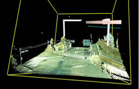
3D Terrestrial Laser Scanner
The system that captures objects and constructions with point cloud data, similar to the airborne laser profiler and MMS. Comparing these products, the 3D Terrestrial Laser Scanner is capable of extraordinary precision. This product offers density of point data capture capability and precise measurements.
Use of 3D Terrestrial Laser Scanner
- Heavy weight tunnel
- Design and implementation of 3D simulation
- Landscape simulation
- Cultural landmarks
- Topographical survey, based on point cloud data
Regarding point cloud data captured with 3D terrestrial Laser Scanner, surprisingly accurate precision and density of survey point data allows the detailed structures to be displayed.
The data is archived and used for different purposes in the future. Archived survey data collects 3D data like a photograph, which is able to support final survey documents.